Already fuller this year than it was at this time a year ago,
Lake Shasta continues to fill, creeping toward the top ―
sometimes rising just inches a day. But by early May, the lake
level is expected to stop rising and the long draw-down of the
lake will begin again and continue through the summer. The lake
is expected to reach about 5 feet from full sometime in early
May, according to Michael Burke, a spokesman for the U.S.
Bureau of Reclamation, which operates Shasta Dam. … Two
years ago, conditions at the lake were dire, with the water
level down to historically low levels. … But with the
lake fuller this year, many water agencies are receiving their
full allotment of water from the bureau.
The governance of San Francisco Bay/Sacramento-San Joaquin
Delta water quality falls under the authority of the State
Water Quality Control Board. Among other duties, the Water
Board is responsible for adopting and updating the Bay-Delta
Water Quality Control Plan for the San Francisco
Bay/Sacramento-San Joaquin Delta Estuary (Bay-Delta
Plan). The Bay-Delta Plan’s purpose sets forth measures
and flow requirements to safeguard various water uses within
the watershed, including municipal, industrial, agricultural,
and ecological needs. Comprising five political appointees with
extensive powers, the Water Board plays a pivotal role in
shaping California’s water management policies. -Written by Cary Keaten, the general manager of
the Solano Irrigation District.
The Bureau of Reclamation today announced the initial 2024
water supply allocations for the Klamath Project along with
$8.5 million in immediate funding for the Klamath Basin
communities to support drought resiliency and $5 million for
Klamath Basin tribes impacted by drought. In partnership with
the Klamath Project Drought Response Agency, Reclamation has
secured $8.5 million for administration of specifically
authorized drought resiliency programs targeted for project
contractors who receive a reduced water allocation. Reclamation
is announcing this funding together with an additional $5
million from separate program sources which will be disbursed
through technical assistance agreements with Klamath Basin
Tribal Nations for drought and ecosystem activities.
The majority of California’s reservoirs are above their
historic average levels following the end of two wet winters.
The state’s largest reservoirs, Shasta Lake and Lake Oroville,
were measured at a respective 118% and 122% of their averages
for early April, according to data from the California
Department of Water Resources. Folsom Lake in the Sierra Nevada
foothills exits early April at 116%. Only two reservoirs, San
Luis in western San Joaquin Valley and Castaic in Southern
California, were below average. San Luis Reservoir was at just
87% and much smaller Castaic Lake in Los Angeles County was at
92%.
Spring storms brought more snow to mountains across the Western
U.S., bringing water for struggling Lake Powell with them. The
National Weather Service Colorado Basin River Forecast Center
on Friday estimated that Lake Powell will receive 5.7 million
acre-feet of water between April and July as snow melts off the
mountains. An acre-foot is roughly enough water to sustain two
houses for a year. That volume is 89% of the normal runoff for
that time period recorded between 1991 and 2020. Facing
extreme drought and climate change since the turn of the
century, Lake Powell dropped to a historic low of 22%
full in Feb. 2023. The reservoir currently stands at
about 32% full.
Last month, the seven U.S. states that use Colorado River water
released two divergent plans for how that water should be
managed after 2026 when the current agreement expires. Their
proposals centered on operations at Lake Powell and Lake Mead,
the country’s two largest reservoirs, the levels of which are
instrumental in determining how much water each state gets. But
a coalition of environmental organizations felt that those
plans — and the discourse surrounding which states should have
to cut their water use — drowned out a crucial consideration:
the environment. So, last week, they submitted a plan of their
own. “Our plan explicitly integrates environmental values and
resources into the planning, while also trying to meet the
needs of people,” Taylor Hawes, the Colorado River Program
director for The Nature Conservancy, said.
Los Angeles Department of Water & Power (DWP) and Mono Lake
Committee staff met this morning at the shore of Mono Lake to
conduct the annual joint reading of the surface elevation of
Mono Lake. The consensus is that the lake stands at 6,383.70
feet above mean sea level which means that Mono Lake is only
halfway to the 6,392-foot elevation level mandated by the
California State Water Resources Control Board 30 years ago to
resolve ecological, wildlife, economic, Tribal, public trust,
and air quality harms caused by the lowering of Mono
Lake. Today’s lake level triggers an important choice for
DWP: Will the Department choose a nearly fourfold increase in
diversions (16,000 acre-feet), or will it choose to leave
exports unchanged (4,500 acre-feet) and preserve the lake level
gains of the record-wet winter of 2023?
It doesn’t look like wastewater will be turned into tap water
in Marin County any time soon. California regulators approved
new rules in December allowing water agencies to purify
wastewater and put it back into the pipes that carry drinking
water to homes, schools and businesses. Officials at the Marin
Municipal Water District said potential projects come with a
high cost and lots of complexities. “Where we stand is we look
forward to continuing to monitor the regulations and larger
agencies,” said Lucy Croy, water quality manager. With that
said, members of the district board said they are interested in
pursuing expansion of its purple pipe system that delivers
recycled water for such purposes as irrigation, toilet flushing
and industrial cooling.
The basin depends on 7,650 acre feet of natural inflow each
year but users pump out nearly 28,000 acre feet annually,
creating a severe overdraft. As the Authority has worked to
comply with the Sustainable Groundwater Management Act (SGMA)
to bring the basin into balance numerous legal actions have
erupted. The Authority restricted pumping for most users. The
U.S. Navy, which operates the China Lake Navale Weapons Base in
the basin, got the lion’s share of pumping. While agricultural
users, such as Mojave Pistachios, which started planting in the
high desert around 2010, received zero pumping allocation.
The Imperial Irrigation District announced in a recent press
report that it has been awarded $7 million in grant funds from
the Department of the Interior in support of the district’s
proposed Upstream Operational Reservoir Project, which would be
the largest reservoir ever constructed in the Imperial Valley
during IID’s 113-year history as an irrigation district. The
announcement was recently made by the Interior Department, with
funds coming from the Bipartisan Infrastructure Law to increase
water supply reliability. This latest grant award to IID is in
addition to a $9.5 million grant previously awarded to the
district for a total of $16.5 million in federal funding for
the Upstream Operational Reservoir Project.
With chronic water shortages afflicting the Colorado River,
discussions about how to cut usage have increasingly focused on
a thirsty crop that consumes an especially large share of the
river’s water: hay that is grown to feed cattle and produce
beef and dairy products. In a new study, researchers found that
alfalfa and other cattle-feed crops consume 46% of the water
that is diverted from the river, accounting for nearly
two-thirds of agricultural water use. The research also shows
that agriculture is the dominant user of Colorado River water,
accounting for 74% of the water that is diverted — about three
times the combined usage of all the cities that depend on the
river. The study presents the most detailed analysis of its
kind to date, including extensive data on where the river’s
water goes across seven Western states and northern Mexico.
… Over the next several years, Pacific Gas and Electric Co.,
the current owner of the Potter Valley Project, is planning to
retire the hydroelectric plant and remove two dams on the Eel
River that provide water for the facility. With power
production shut down, tunneling water into the Russian River
won’t be necessary. … The Potter Valley Project provides a
portion of the water supply for large swaths of Mendocino and
Sonoma counties. … Scores of vineyards here are tethered
to water rights that are subject to restriction when river
levels drop. During the recent drought, hundreds of
water-rights holders were forced to stop pumping — a
scenario many believe was a preview of a future where the Eel
River doesn’t continue to supplement the Russian.
The Marin Municipal Water District is taking a closer look at
storage expansion projects that could increase capacity for
billions of gallons of additional water to defend against
drought. After several months of study, district officials and
consultants are considering projects that could include raising
dam heights and some possibilities for creating new dams. Each
option would increase the storage capacity by about 20,000
acre-feet. The proposals include expansions of Alpine Lake,
Kent Lake and the Soulajule and Nicasio reservoirs. The
district is also looking at constructing new reservoirs in the
areas of Devil’s Gulch, Halleck Creek and upper Nicasio. The
proposals were presented to the water board at its meeting on
March 19.
The frustration for farmers continues to grow after recent news
of recent water allocation numbers. The Bureau of Reclamation
has announced a 35 percent federal allocation for Central
Valley Project recipients, as the California Department of
Water Resources has allocated 30 percent of State Water Project
requests. The news comes as the snowpack in the Sierra
Nevada sits at or near normal. … Joe Del Bosque of Del
Bosque Farms … says he and other farmers were extremely
disappointed with the recent numbers. He tells me with the
current snowpack, and recent, and potentially incoming storms,
the allocation should have been higher.
… Lake Powell’s levels have fallen throughout the winter, but
as the weather warms, the snowpack that has accumulated in the
mountains over the winter will begin to melt. That water will
feed rivers and streams across the West — including the
Colorado River, which fills Lake Powell on Arizona and Utah’s
shared border. … The National Weather Service Colorado
Basin River Forecast Center predicts that 5.4 million acre-feet
of unregulated runoff will spill into the reservoir between
April and July. … According to the Colorado Basin River
Forecast Center, spring runoff this year will be 85% of the
average runoff between 1991 and 2020.
The Colorado River is relied upon by roughly 40 million people.
That includes members of 30 federally-recognized tribes, as
well as residents across seven states. Four of those are in the
region known as the Upper Basin – that includes Colorado, Utah,
Wyoming, and New Mexico – and the other three are in the Lower
Basin – California, Arizona, and Nevada. In Colorado alone,
half of Denver’s supply – as well as half of Colorado Springs’
supply – rely on the river. Tribal nations in Colorado,
New Mexico, Utah and Wyoming have been left out of key
agreements involving the Colorado River for well over a century
now.
Two-thirds of the tribes with lands and water rights in the
Colorado River Basin are calling for equal status in developing
new river management guidelines and protection of their senior
water rights against proposed cuts or caps on developing their
water. Leaders from 20 tribes, including eight in Arizona, sent
a letter to the U.S. Bureau of Reclamation March 11. In the
letter, obtained by The Arizona Republic, the tribes outlined
what they expect in new river management guidelines that will
take effect when the current guidelines expire Dec. 31, 2026.
The two tribes with Arizona’s largest river allocations — the
Colorado River Indian Tribes, which holds senior rights to
720,000 acre-feet of water, mostly in Arizona, and the Gila
River Indian Community, with 653,000 acre-feet of Colorado
River and other waters — did not sign the letter.
State officials on Friday doubled the amount of water
California agencies will get this year following some strong
storms that increased the snowpack in the mountains. The State
Water Project is a major source for 27 million people. The
majority of contractors who supply the water are located south
of the Sacramento-San Joaquin River Delta. Previously, the
Department of Water Resources had told them to expect 15% of
their requests this year. The department increased that to 30%
on Friday. The department said contractors north of the delta
can expect 50% of their requests, while contractors in the
Feather River Settlement can expect 100%.
Lake Powell remains at the center of attention as the seven
Colorado River Basin states figure out how much water is
withdrawn from it this year and beyond. But those who rely on
it for water and electricity — and the millions who enjoy
recreating on the reservoir — are equally focused on how much
Lake Powell receives this spring. The good news is, it is
expected to receive a decent bump in the coming months. The bad
news is, it’s not expected to reach the same levels it peaked
at before the region’s latest severe drought. Lake Powell
is projected to receive about 5.4 million acre-feet of water
based on conditions this winter, National Weather Service’s
Colorado Basin River Forecast Center officials said on Friday.
That would hoist the reservoir from 32% to 37% capacity after
the snowmelt process wraps up in the early summer.
California regulators this week proposed delaying new rules
aimed at reducing how much water people use on their lawns,
drawing praise from agencies that said they needed more time to
comply but criticism from environmentalists who warn that the
delay would damage the state’s already scarce supply. Last
year, California proposed new rules that would, cumulatively,
reduce statewide water use by about 14%. Those rules included
lowering outdoor water use standards below the current
statewide average by 2035. On Tuesday, regulators proposed
delaying that timeline by five years, until 2040. The State
Water Resources Control Board is scheduled to vote on the rules
later this year. The state would not punish people for using
too much water on their lawns.
… A windswept county in the Sacramento Valley — whose
entire population of 22,000 people is just one-third of Palo
Alto’s — may soon be known for something else: the largest new
reservoir anywhere in California in the past 50 years. Last
weekend, President Biden signed a package of bills that
included $205 million in construction funding for Sites
Reservoir, a proposed $4.5 billion project planned for the
rolling ranchlands west of the town of Maxwell, about 70
miles north of Sacramento. … The make-or-break moment
for Sites is a series of hearings scheduled to run from June to
November in which the State Water Resources Control Board will
analyze fisheries studies and other documents and decide
whether to award it the water rights to move forward.
The Sacramento Superior Court has ruled in favor of the State
Water Board’s 2018 Bay Delta Plan update, denying all 116
claims by petitioners. In December 2018, the State Water
Resources Control Plan adopted revised flow
objectives for the San Joaquin River and its three major
tributaries, the Stanislaus, Tuolumne, and Merced rivers. The
new flow objectives provide for increased flows on the three
tributaries to help revive and protect native fall-run
migratory fish populations. The Board also adopted a revised
south Delta salinity objectives, increasing the level of
salinity allowed from April to August. Several petitions
were filed in several counties challenging the Board’s
action.
Sacramento and cities across California caught a break from the
state’s water regulator this week after the agency faced
criticism that its water conservation rules were too
complicated and costly to meet. Regulators at the State Water
Resources Control Board proposed new conservation rules Tuesday
that would ease water savings requirements for urban water
suppliers and will ultimately lead to less long-term water
savings than initially planned. Under the new rules, the city
of Sacramento would have to cut its overall water use by 9% by
2035 and 14% by 2040, far less than an initial proposal that
would have required it to cut back water use by 13% by 2030 and
18% by 2035.
A new recommendation from the California State Water Quality
Control Board in its Bay-Delta Water Quality Control Plan
(Bay-Delta Plan) for the San Francisco Bay/Sacramento-San
Joaquin Delta Estuary could see Solano County forced to adapt
to a fraction of the water it is currently allocated from Lake
Berryessa. The implications for Solano County cities could be
enormous, leaving Solano County with about 25 percent of its
current allocation. Spanning hundreds of miles from north of
Lake Shasta to Fresno, the tributaries of the Sacramento and
Sac Joaquin rivers that feed into the San Francisco Bay reach
well into the Sierra Nevadas and Central Valley. The State
Water Quality Control Board has noted that diminished river
flows in these areas are harming fish habitats and are
detrimental to the water system as a whole ecologically.
Congress has given the green light for a significant boost to
the Sites Reservoir Project, based on a recommendation from the
Bureau of Reclamation. A total of $205.6 million in federal
funds is being allocated. The money comes from the Water
Infrastructure Improvements for the Nation (WIIN) Act, which
helps enhance water systems across the country. It marks the
largest single award in the history of the WIIN Act for a
storage project. … The Sites Reservoir aims to bolster
water supplies across California while also supporting native
wildlife during droughts. This project will add 1.5 million
acre-feet of storage, significantly enhancing the state’s water
flexibility and reliability during dry years. Last summer, the
project received $30 million from the Infrastructure Investment
and Jobs Act, making the total federal contribution to date
$439.3 million.
Across the parched West, there are signs the region’s
decades-long population and housing boom is confronting the
realities of dwindling water supplies. These have come in
recent months from court rulings and executive edicts alike, as
states crack down on the potential for new users to draw from
already oversubscribed aquifers and surface waters. The
skeleton of a would-be subdivision outside Las Vegas
illustrates the coming constraints, stymied by a lack of water
to support the new community. Water shortages also forced
difficult decisions in other places, such as new restrictions
in the Phoenix suburbs and a Utah town that halted all new
construction for more than two years until it could secure a
new well.
A government agency that controls much of California’s water
supply released its initial allocation for 2021, and the
numbers reinforced fears that the state is falling into another
drought. The U.S. Bureau of Reclamation said Tuesday that most
of the water agencies that rely on the Central Valley Project
will get just 5% of their contract supply, a dismally low
number. Although the figure could grow if California gets more
rain and snow, the allocation comes amid fresh weather
forecasts suggesting the dry winter is continuing. The National
Weather Service says the Sacramento Valley will be warm and
windy the next few days, with no rain in the forecast.
The growing leadership of women in water. The Colorado River’s persistent drought and efforts to sign off on a plan to avert worse shortfalls of water from the river. And in California’s Central Valley, promising solutions to vexing water resource challenges.
These were among the topics that Western Water news explored in 2018.
We’re already planning a full slate of stories for 2019. You can sign up here to be alerted when new stories are published. In the meantime, take a look at what we dove into in 2018:
People in California and the
Southwest are getting stingier with water, a story that’s told by
the acre-foot.
For years, water use has generally been described in terms of
acre-foot per a certain number of households, keying off the
image of an acre-foot as a football field a foot deep in water.
The long-time rule of thumb: One acre-foot of water would supply
the indoor and outdoor needs of two typical urban households for
a year.
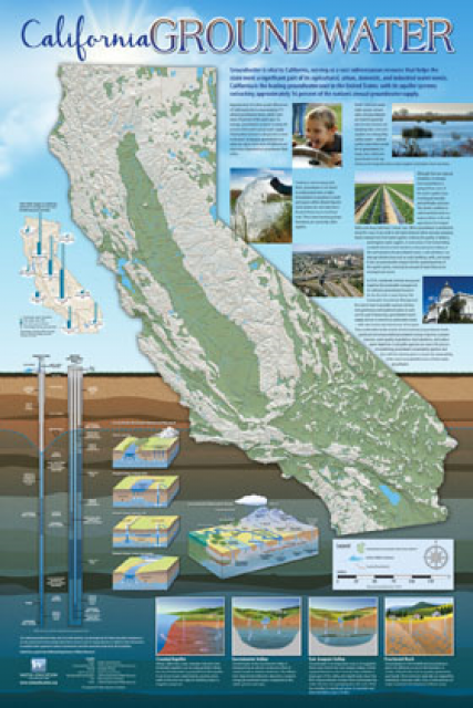
Fashioned after the popular California Water Map, this 24×36 inch
poster was extensively re-designed in 2017 to better illustrate
the value and use of groundwater in California, the main types of
aquifers, and the connection between groundwater and surface
water.
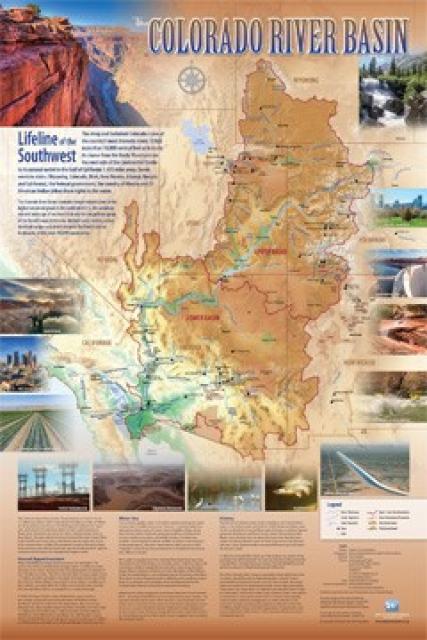
Redesigned in 2017, this beautiful map depicts the seven
Western states that share the Colorado River with Mexico. The
Colorado River supplies water to nearly 40 million people in
Arizona, California, Colorado, Nevada, New Mexico, Utah, Wyoming
and Mexico. Text on this beautiful, 24×36-inch map, which is
suitable for framing, explains the river’s apportionment, history
and the need to adapt its management for urban growth and
expected climate change impacts.
As the state’s population continues to grow and traditional water
supplies grow tighter, there is increased interest in reusing
treated wastewater for a variety of activities, including
irrigation of crops, parks and golf courses, groundwater recharge
and industrial uses.
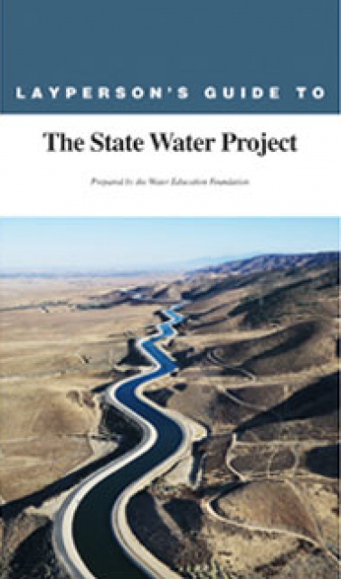
The 24-page Layperson’s Guide to the State Water Project provides
an overview of the California-funded and constructed State Water
Project.
The State Water Project is best known for the 444-mile-long
aqueduct that provides water from the Delta to San Joaquin Valley
agriculture and southern California cities. The guide contains
information about the project’s history and facilities.
The 24-page Layperson’s Guide to Integrated Regional Water
Management (IRWM) is an in-depth, easy-to-understand publication
that provides background information on the principles of IRWM,
its funding history and how it differs from the traditional water
management approach.
The 24-page Layperson’s Guide to Flood Management explains the
physical flood control system, including levees; discusses
previous flood events (including the 1997 flooding); explores
issues of floodplain management and development; provides an
overview of flood forecasting; and outlines ongoing flood control
projects.
The 24-page Layperson’s Guide to California Water provides an
excellent overview of the history of water development and use in
California. It includes sections on flood management; the state,
federal and Colorado River delivery systems; Delta issues; water
rights; environmental issues; water quality; and options for
stretching the water supply such as water marketing and
conjunctive use. New in this 10th edition of the guide is a
section on the human need for water.
The 24-page Layperson’s Guide to the Central Valley Project
explores the history and development of the federal Central
Valley Project (CVP), California’s largest surface water delivery
system. In addition to the project’s history, the guide describes
the various CVP facilities, CVP operations, the benefits the CVP
brought to the state and the CVP Improvement Act (CVPIA).
The 24-page Layperson’s Guide to the Delta explores the competing
uses and demands on California’s Sacramento-San Joaquin Delta.
Included in the guide are sections on the history of the Delta,
its role in the state’s water system, and its many complex issues
with sections on water quality, levees, salinity and agricultural
drainage, fish and wildlife, and water distribution.
A new look for our most popular product! And it’s the perfect
gift for the water wonk in your life.
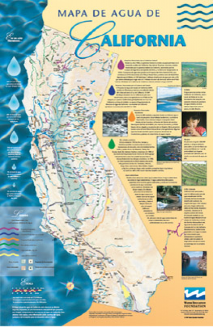
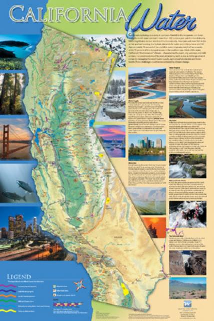
Our 24×36 inch California Water Map is widely known for being the
definitive poster that shows the integral role water plays in the
state. On this updated version, it is easier to see California’s
natural waterways and man-made reservoirs and aqueducts
– including federally, state and locally funded
projects – the wild and scenic rivers system, and
natural lakes. The map features beautiful photos of
California’s natural environment, rivers, water projects,
wildlife, and urban and agricultural uses and the
text focuses on key issues: water supply, water use, water
projects, the Delta, wild and scenic rivers and the Colorado
River.
An acre-foot is a common way in the U.S. to measure water volume
and use. It is the amount of water it takes to cover an acre of
land one foot deep. An acre is about the size of a football
field.
An acre-foot of water equals 325,851 gallons, and historically
that was enough to serve the needs of two families for a
year in California.
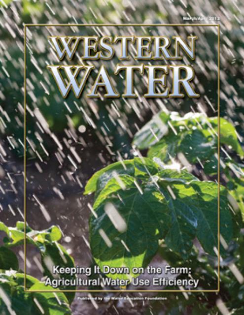
This printed issue of Western Water examines
agricultural water use – its successes, the planned state
regulation to quantify its efficiency and the potential for
greater savings.
This issue updates progress on crafting and implementing
California’s 4.4 plan to reduce its use of Colorado River water
by 800,000 acre-feet. The state has used as much as 5.2 million
acre-feet of Colorado River water annually, but under pressure
from Interior Secretary Bruce Babbitt and the other six states
that share this resource, California’s Colorado River parties
have been trying to close the gap between demand and supply.


: Karla Nemeth, director, California Department of Water Resources; Gloria Gray, chair, Metropolitan Water District of Southern California; Brenda Burman, Bureau of Reclamation Commissioner; Jayne Harkins, commissioner, International Boundary and Water Commission, U.S. and Mexico; Amy Haas, executive director, Upper Colorado River Commission.")
")